Snapshot
Route: Port de Pollença → Cap de Formentor (lighthouse) → return
Distance & elevation: ~38–42 km, ~1200m total climbing
Surface: Good tarmac; spectacular views; one short lit tunnel
Ride time (moving):
- Strong: 1h45–2h15
- Fit: 2h15–3h
- Steady: 3h–4h
Difficulty: Intermediate to advanced (exposure + wind + traffic)
Best start: Early or late afternoon; avoid lunch hour tourist traffic
How It Works
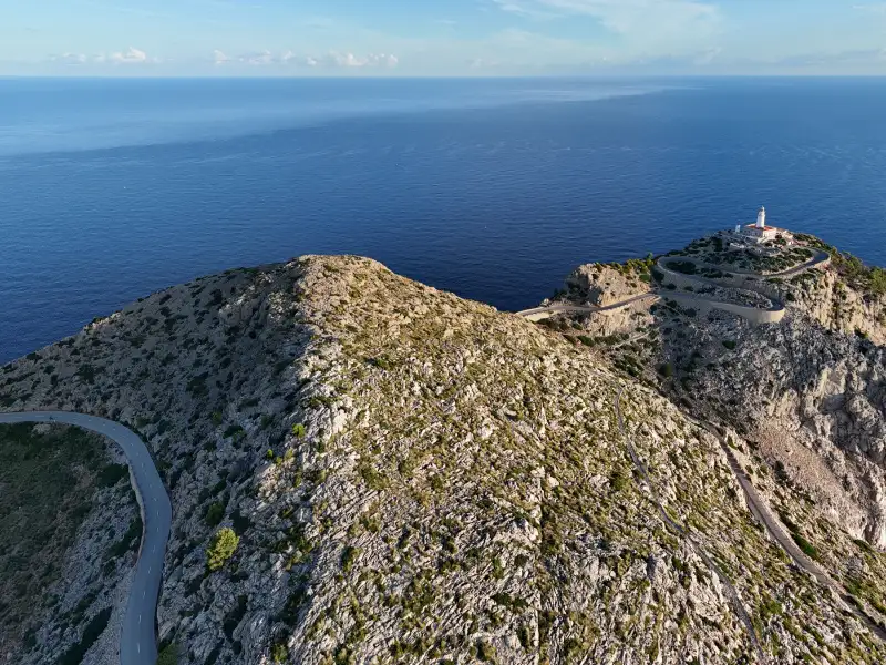
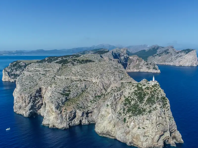
This is an out-and-back ride on the Ma-2210 featuring two and a half main climbing sections: 1. the Coll de Sa Creueta ascent to Mirador Es Colomer, then on the return there is a cheeky short (half!) hill up from the lighthouse and then from Formentor beach back up to Mirador Es Colomer. The rest is a roller-coaster of short climbs and descents. Expect the return journey to be much quicker than the outward.
Optional add-ons include the very steep Talaia d’Albercutx side road with a sketchy surface (only for confident climbers) or a relaxing pause at Platja de Formentor.
If you are staying locally it’s a must do. If you are staying further afield, take a scheduled shuttle or book a private shuttle to Port de Pollença.
Segment Breakdown
Port de Pollença → Mirador Es Colomer (Coll de Sa Creueta)
Distance: 4 km Gradient: ~6–7% with hairpins Highlights: Spectacular coastal viewpoint at the top Hazards: Occasional tour buses Bail-out: None until the top
This initial climb features steady gradients with hairpin bends carved into the hillside. The Mirador Es Colomer viewpoint at the summit offers breathtaking views over the dramatic cliffs and is a perfect photo stop.
Mirador → Formentor Beach (Platja de Formentor)
Distance: about 4km sweeping downhill Gradient: 5-6% Highlights: Coastal scenery, forest, sweeping/swooping descent! Hazards: Narrow sections, limited visibility on some corners Food/water: Seasonal café at beach (unreliable hours, high prices)
The road opens up with stunning Mediterranean views on the descent to the beach area.
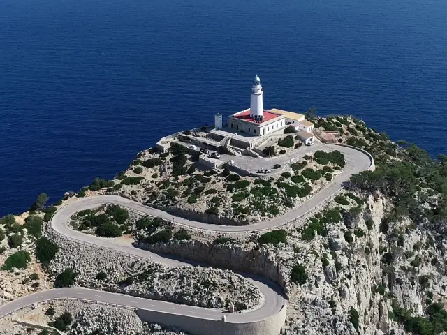
Beach → Lighthouse (Faro de Formentor)
Distance: Final push to the lighthouse 7.5km Gradient: Several punchy ramps Highlights: Exposed ridge riding, sea views, forest, small vineyard Hazards: Wind exposure occasionally, goats, final ramp bites hard on return Bail-out: Turn around wherever you need
Segment Summary Table
| Segment | Distance | Typical Time | Gradients | Key Hazards | Bail-out/Food |
|---|---|---|---|---|---|
| Port de Pollença → Mirador | 4 km | 15-25 min | 6-7% | Narrow road, buses | None |
| Mirador → Beach | 4 km | 10 min | 5% | Dew, pine needles | Beach & Mirador café (seasonal) |
| Beach → Lighthouse | 7-8 km | 20-40 min | Punchy ramps | Windy days, goats | Turn at beach |
| Total out | ~19-21 km | ~55-100 min | Mixed | Various | Multiple |
| Total return | ~19-21 km | ~50-90 min | Reverse profile | Same + tired legs | Same |
Map & Files
Classic out-and-back to the lighthouse featuring two main climbing sections, coastal views, short tunnels, and exposed ridges. The most popular way to experience Cap de Formentor.
Challenging variant adding the very steep Talaia d'Albercutx side road from Mirador Es Colomer. Features gradients of 10-14%+ on rough surfaces with spectacular 360° views. For confident climbers only.
Epic route combining the spectacular Cap de Formentor lighthouse with a ride down to Playa de Palma. Start with the iconic Formentor out-and-back before heading south through the Tramuntana foothills to the coast.
Complete the classic coast to coast but include what is regarded by some as the best 20km of road for cyclists in Europe - the out and back to the lighthouse of Cap de Formentor. Epic day out!
Timing Strategy (Traffic & Weather Reality)
Seasonal Vehicle Restrictions
Seasonal vehicle restrictions to the lighthouse apply from June to October (no cars beyond certain points, only hourly tourist buses) – cyclists are always allowed.
In 2025, restrictions were in place from 1st June to 31st October. In 2026, there is ongoing debate about extending vehicle restrictions to include May so pedal power can rule for longer (fingers crossed!).
Wind Considerations
On windy days, gusts can make the exposed ridges challenging. Be wise and consider turning back if conditions become unsafe. Check wind forecasts before heading out.
Heat & Sun
Minimal shade on this route apart from the 3 or so kilometres between the beach and the tunnel where you go through the pine forest. Plan for adequate water and sunscreen, especially in the hotter months. Formentor beach is your friend for a cooling break and refill opportunity (when seasonal facilities are open).
Best Timing
- Sunrise to mid morning: Magical light, minimal traffic, cooler temperatures
- Late afternoon: Good light for photos, less traffic
- Avoid: Late-morning (12:30-14:00) when tour traffic peaks
Safety & Etiquette
- Lights: Front and rear lights mandatory for tunnels; remove sunglasses inside
- Descending: Stay within sight lines – blind bends and narrow bridges require caution
- Road hazards: Watch for goats, rockfall, pine cones, and damp patches under trees
- Traffic: Single-file when busy; give way to others in pinch points
- Permits: No drones in the park without permits; respect all signage
- Emergency: Call 112 and share exact location (km post or WhatsApp location pin)
- Rescue plan: Ensure you have your Mallorca Bike Rescue policy if bike or body let you down
Water, Food & Facilities
Port de Pollença (Start/Finish)
Full services available: cafés, restaurants, supermarkets, bike shops, toilets.
Es Mirador (Summit)
Seasonal operation, basic snacks and drinks, portaloo available (check opening hours for both loo and café!)
Formentor Beach (Platja de Formentor)
Seasonal hotel/café may be open; expect high prices and variable hours.
Lighthouse Café
Seasonal operation; sometimes closed without notice in bad weather. Generally open March to October 10:00 to 16:00.
Water Strategy
Don’t rely on mid-route refills in case cafés are closed. Start with 2 full bottles.
Essential Equipment
- Lights: Mandatory for tunnels (front and rear)
- Layers: Wind shell for descents; weather can change quickly
- Spares: Whatever you need to fix a puncture
- Money: Cash and card (some facilities card-only, others cash-only)
- ID & phone: Carry photo ID; WhatsApp works well for emergency location sharing
Rider Profiles
First-timers to Mallorca
Recommendation: Turn around at Formentor Beach if in any doubt about fitness, weather, or time. The lighthouse section is more exposed and challenging.
Intermediate Groups
Recommendation: The full lighthouse route is achievable and brilliant. Regroup before descents and tunnels. Set a turnaround time and stick to it.
Strong/Experienced Riders
Recommendation: Consider adding the Talaia d’Albercutx spur from the Mirador (steep ramps 10–14%+, rough surface, stunning views). Only attempt if confident with steep, technical climbing and descending.
Variations & Bail-outs
Short Day Option
Port de Pollença ↔ Formentor Beach only ~20 km total, cuts out a lot of climbing while still delivering spectacular scenery.
Photo Stop Loop
Add Talaia d’Albercutx from the Mirador Very steep ramps (10–14%+), rough surface, absolutely stunning 360° views. Descend with extreme care – loose gravel, holes and steep gradients.
Photo Spots
Mirador Es Colomer
Park safely off the road in designated areas. Iconic clifftop views looking down the peninsula.
Tunnel Exits
Only stop at tunnel entrances/exits where there are safe lay-bys – never inside or immediately outside tunnels.
Lighthouse
Limited space. Be quick and considerate of other visitors.
Wildlife Shots
Never stop on blind corners. Goats are unpredictable models and you may cause them to run in the road.
Mallorca Bike Fotos
Professional photographers from Mallorca Bike Fotos are stationed at Es Colomer de Formentor and just before the lighthouse, capturing iconic action shots of you in motion. Photos are uploaded every evening – check them out online after your ride.
Good to Know (Quick Hits)
- Mobile signal: Generally OK but can drop near cliffs and in valleys
- Road surface: Really nice – take extra care on descents that speed does not overcome skill
- Shade: Scarce throughout the route – sunscreen and electrolytes essential even in shoulder seasons
- Wildlife: Goats can appear unexpectedly on the road
- Traffic: Seasonal restrictions help but it gets busy in April and May 12:00 - 14:00
- History: Like Sa Calobra, this road was designed by engineer Antonio Parietti in the 1920s-30s
Frequently Asked Questions
Is the road closed to cars?
Yes (typically June–October 10:00 - 22:00, possibly extending to May in 2026). Cyclists are usually allowed at all times – check current rules before you go.
Is there water available en route?
Don’t bank on it. Start with 2 full bottles.
Is it suitable for beginners?
Only if you’re fit, confident with descents and traffic, and willing to turn around at the beach if needed.
Can I ride an e-bike?
Yes, but mind your battery, keep some power for the return. Consider keeping assist on low settings outbound.
What’s the best time of year?
Spring (March–May), June and autumn (September–October) offer the best conditions: mild temperatures, lower traffic, and beautiful light. Summer can be very hot, so an early start is vital.
Should I take the Talaia d’Albercutx detour?
Only if you’re confident with very steep (10–14%+) gradients on rough surfaces and technical descending. The views are spectacular but it adds significant difficulty.
What if I have a mechanical?
Make sure you have an active Mallorca Bike Rescue policy before heading out.
Getting Started
Ready to tackle Cap de Formentor? Whether you’re staying in Port de Pollença or elsewhere on the island, proper planning makes all the difference.
Consider booking a Mallorca Cycle Shuttle to Port de Pollença if you’re based further away. Check the scheduled bike buses for convenient departure times.
And don’t forget to puchase your bike rescue policy before you ride – peace of mind for you and your group.
Enjoy one of Mallorca’s most spectacular coastal rides!
Related Cycling Routes
Want to explore more of Mallorca’s legendary climbs? These routes are also essential:
- Sa Calobra Guide - Mallorca’s most famous climb with 26 hairpins and the iconic spiral bridge
- Andratx to Pollença (MA-10) Guide - The complete 60km journey through the Tramuntana mountains
- Big Daddy Challenge - Take on all major climbs including Cap Formentor in one epic ride